
My Guide to Summiting the Three Peaks: at a leisurely pace, rather than in 24-hours
The Three Peaks are the highest points of the three countries that comprise Great Britain: Ben Nevis in Scotland (1,345m), Snowdon in Wales (1,085m) and Scafell Pike im England (978m). Some people attempt a gruelling challenge to summit all three within 24 hours, sleeping during the two long drives between the mountains and summiting at least one of them at the dead of night.
I researched the challenge a few years ago and not only is it fairly expensive to pay for the travel and support driver, I can’t say I fancied the exhaustion and it seemed to me a huge waste to not see any of the beautiful surrounding mountain ranges: the Grampians in the Scottish Highlands, the Lake District in England, and Snowdonia in Wales. So instead I’ve tackled the Three Peaks on individual trips, seeing so much more of the regions and avoiding filling a weekend with sleep deprivation. Here’s my brief guide to doing the Three Peaks in a slower, more appreciative fashion:
Snowdon & Snowdonia, Wales (August 2015)
Over a long summer weekend, seven friends and I trekked over to Snowdonia in north Wales to attempt the ‘Welsh 3000s’ over three days. These are 15 peaks over the height of 3,000 feet, all within close proximity, we clocked up a total of 50km over the three days. They were three very long days but not 15 vertical ascents – no fear! You do one big ascent each day, and then walk between the peaks nearby, with a little up an down but nothing too impossible. Our total elevation gain over the three days was 3,300m. This can be attempted as a 24-hour challenge in itself and we did see some astonishing fell runners attempting the feat (crazy people!), but we opted for the more relaxed 3-day version.


On the final day we scrambled across the infamous “knife’s edge” ridge called Crib Goch, where people have occasionally fallen to their deaths. I confess that the steep, deadly drop’s either side of the Crib Goch ridge did terrify me, especially with slightly slippery wet rocks and an ominous fog, but we happily made it to the other side and on towards Snowdon itself as our very last peak of the weekend. There is a passenger train carrying less active visitors to the summit, and even a restaurant at the top, so it’s understandably far far busier than any other peak in the area, and less special because of it. The summit is also notoriously shrouded in cloud, producing zero view, and it was pretty poor visibility when we summitted on two feet. I much preferred the other virtually empty peaks we hiked to that weekend.


Routes to Snowdon are well marked and well-trodden so you can just follow the line of people to the summit, but to reach the other peaks you’ll need a map and compass skills, whether the old-fashioned paper and plastic versions of the OS Map app on your phone (with a battery pack & charging cable just in case). This shouldn’t be underestimated, as there are no signs on the other mountains. Our party was led by a friend Nick who’d valiently taken on the challenge of guiding us, and he only made one mistake the entire weekend – one that remains etched into all of our memories as it involved a 2-hour steep descent through dense heather, sliding down on our bottoms at points, and a long exhausting walk back along the valley floor.


Ben Nevis & The Highlands, Scotland (June 2019)
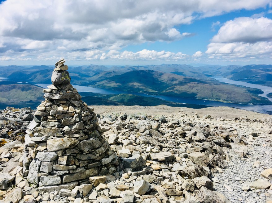
A few years passed before I returned to the challenge, hoping to manage it in time for my 30th birthday as one of my ‘30 Before 30’. My mother and I flew up to Glasgow and then travelled to Fort William, the town nearest Ben Nevis. For a more atmospheric if expensive journey, you can take the sleeper train to Fort William, complete with a dining carriage and pretty comfortable bunk bed rooms. Other options by road include driving a hire car or taking a 3-hour bus from Glasgow, or flying into Inverness and travelling by road from there. We stayed at this adorable Airbnb in Fort William hosted by Stuart, and took a short bus to the base of Ben Nevis to attempt our ascent. There is only one principal route up, so once you’ve found the beginning then you don’t need a map and compass, as the path is well-built and you should be following in the footsteps of others as it’s another popular mountain to climb. The summit is covered in cloud 9 days out of 10 so we were exceptionally lucky to have complete visibility the whole way up and these views at the summit.


As the highest peak in Britain at 1,345m it’s a substantial achievement to get to the Ben Nevis summit, but it isn’t technically complex and the number of other people summiting with us slightly detracted from our sense of satisfaction, so again it wasn’t my favourite hike in the region. You descend by the same path you’ve ascended, and if you time it carefully you can catch a bus back into Fort William, or call a taxi.


I much preferred the other two hikes we did from Fort William. On day 1 we warmed up with a shorter 12.5km hike around Cow Hill, marginally dodging a brief but torrential downpour of rain (see our route up Cow Hill on Strava here).


On day 3 we hiked the Ring of Steall, which is one valley over from Ben Nevis. It’s a 20km hike and much more demanding (and beautiful, deserted, satisfying) than Ben Nevis. It took us 11 hours in total however so is a serious endeavour – only attempt it if you are physically fit enough. I’d seriously recommend walking poles for the really long initial ascent after you’ve started the hike by paying a visit to Steall Falls, by crossing a three-wire bridge across a river to get there. Once up at the first Munro of the day (that means a Scottish mountain above 914m (3000ft)) you then have a gentle walk clockwise along the ridge of the whole valley reaching four Munros, before you make the very long descent back down the valley floor and home.


Between the third and fourth Munro, a sudden and unexpected thunder storm descended upon the whole mountain range and we were both struck by lightening. It felt very bizarre: a sharp sudden shock on the tops of both of our heads, a quick flash of very bright light and a loud crack sound in our ears. I turned around to check if my mother had seen it and she’d experienced the very same sensations. Thankfully neither of us suffered anything worse and we managed to continue our hike, although of course feeling very shaken and worried about how exposed we still were up high on the mountain with nowhere to take shelter from further lightening. While descending we saw a helicopter hover above us briefly, before flying onwards elsewhere.


The next day we awoke to national news reporting that a woman hiking just an hour away from us had been killed by a lightening strike, and it dawned on us how lucky we were to have survived the shock we experienced – our only guess is that it must have been an incredibly low charge. This however is unusual, and I wouldn’t let this freak accident put you off hiking! Even despite this near-death experience, I still enjoyed he hike overall as we barely saw 10 other people in the whole valley, compared to the hundreds on Ben Nevis just 24 hours beforehand.

Worth noting: the Scottish Highlands are apparently infested with midges in the height of summer (July/August) so I’ve been recommended by various people to avoid those months. Early June was thankfully totally midge-free.
Scafell Pike & The Lake District, England (August 2019)
My first visit to the Lake District had focused on Keswick and Derwentwater Lake, but on this most recent trip with my father we based ourselves in the town of Ambleside in a cute B&B run by two mountain guides, 2 Cambridge Villas. Our trip coincided with fantastic weather so we succeeded in summiting Scafell Pike on our first day in the region. There are four different routes up the mountain, varying greatly in difficulty, length and popularity. Keen to avoid the crowds of Ben Nevis, we avoided the fastest, most crowded route (up-and-down in 4 hours from Wasdale) and instead we opted for the longest route from Langdale Valley (up-and-down in 8 hours), which was far emptier and more enjoyable!


That route starts with a few relaxed kilometres along The Valley floor before a gradual ascent to Angle Tarn, a small lake at 564m height where we stopped for lunch and saw a couple of wild campers with their tents – an inspired idea and something I’d like to try. Continuing up we were fooled by many a false peak and eventually reached the hard-to-navigate piles of boulders that radiate from the summit of Scafell Pike. Fortunately we again had 100% visibility, which I’m told is equally as unusual as for Ben Nevis! We also found a true crowd of other hikers from the shorter 4-hour route, some of whom were even in jeans and trainers, which somewhat dampened our sense of achievement there too!


We returned the way we’d come, although detoured to summit nearby Esk Pike at 885m, which was empty and do much more magical because of it! The detour added an hour or so to our hike however, and we descended from Esk Pike back to Angle Tarn and retraced our steps to Langdale valley. A 21km hike in total, with an elevation gain of 1,195m (equal to 330 flights of stairs!) and my favourite of the Three Peaks because we’d chosen the path less-trodden.

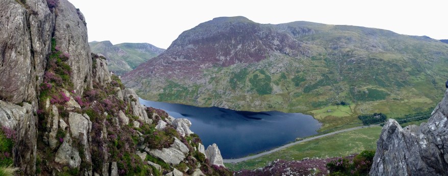
On Day 2 we hiked west of Glenridding, up towards another famous peak called Hellvellyn. Listening to our leg muscles crying out against another major ascent, we hiked as far as a beautiful lake called Red Tarn and then turned back, returning via a gentle and deserted descent into pretty Grisedale Valley to the south of our ascent. It was a scorching hot day but once we’d picked up the breeze along the ridge of the mountain, it was stunning and one of my favourite hikes (see our route up Glenridding on Strava here). At only 4 hours long, we got home to our B&B in Ambleside in time for bubbles with sunset. For dinners, I can particularly recommend Lucy’s on a Plate, with a scrumptious menu and tailor made menu giving shout outs to all its customers that evening!


On Day 3 we opted for a low valley walk starting in Elterwater, meandering along a river and next to some impressive waterfalls, through forests and across fields. This is a gentler 9km, 3 hour hike, which is good for shade and less utterly exhausting, so was a good option for us before the long journey back down to the south of England. See our route up Elterwater on Strava here.
_______________________
Overall I far prefer my slow-and-steady version of the Three Peaks, getting decent nights’ sleep in between hikes, seeing them all in daylight, exploring the less popular surrounding peaks too, truly enjoying each hike rather than focusing on sheer survival.
I’d love to hear from someone who has actually done the 24-hour Three Peaks Challenge and ask how did you find it? Was the experience worth it or would you prefer my slower version?
And if you’ve been to any of these three regions, which are your favourite hikes?


Listen to my Podcast


I’m with you all the way with the slow travel version of the three peaks. You actually got to see and enjoy the amazing scenery and countryside around all three locations which the 24 hour racers certainly don’t. Much better and interesting that you liked Scafell Pike the most. Great photos.
LikeLike
Nice blog post – I also agree it’s better to do them separately. Although, if you’re anything like me and crave a challenge minus the sleep deprivation, you could try the Yorkshire Three Peaks. 12 hours, 3 peaks and one iconic railway viaduct!
LikeLike
Ooh I’ll look into that! If it’s all in daylight then I’d be fine with that!
LikeLike
I agree it’s nicer to spread the Three Peaks over a few trips, and have time to explore the paths less-travelled and surrounding area. I first climbed Snowdon when I was twelve (or thereabouts) and have climbed it a few times since, though am yet to attempt Crib Goch. I enjoyed Scafell Pike and the surrounding area a lot as it was much less crowded; perhaps down to timing (outside school holidays), perhaps due to the admittedly sub-par weather (the summit was enveloped in thick cloud, so zero views). I did Ben Nevis after the West Highland Way, and it was well worth the early (half six ish) start, as there were only a few of us at the summit. Completely different story for those coming up as we made our way back down – the path was like a motorway of walkers!
LikeLike
Yes, the trick is to avoid the crowds – it makes the whole thing feel much more of an achievement! We opted for summer so had little choice, but at least had views at two of the three!
LikeLiked by 1 person
I find an early start often helps when it comes to beating the crowds. Luckily, there are lots of less well-known but equally beautiful peaks to explore around Ben Nevis, Scafell Pike and Snowdon. I really enjoyed hiking up Yewbarrow (north of Scafell Pike, on the other side of Wastwater) as there was no one else there!
LikeLike
Thanks for suggesting Yewbarrow, I shall look into it!
LikeLiked by 1 person
Great job Virginia, well done, it’s something I would love to do one day ! Hiking is one of my fave activities. Incidentally, have you ever thought of taking part in one of the Oxfam Trailwalker events, they can also be quite tough but again you can go at your own pace, which most ordinary people (read: not professional athletes) do. I took part on seven occasions here in Hong Kong and loved it, here’s the website which you might find interesting – https://www.oxfamtrailwalker.org.hk/
Best regards, Ben
LikeLike
Oh that’s good to know, I’ll look into those!
LikeLike